
Introduction
A Wyoming county map is an essential tool for anyone looking to explore, understand, or navigate the vast and scenic landscapes of Wyoming. The state is known for its breathtaking natural beauty, rugged terrain, and wide-open spaces. Understanding the counties within Wyoming can help residents, travelers, and researchers make informed decisions about routes, attractions, demographics, and historical significance. This article will provide an in-depth look at the Wyoming county map, detailing each county’s geographical, historical, and economic features.
Overview of Wyoming Counties
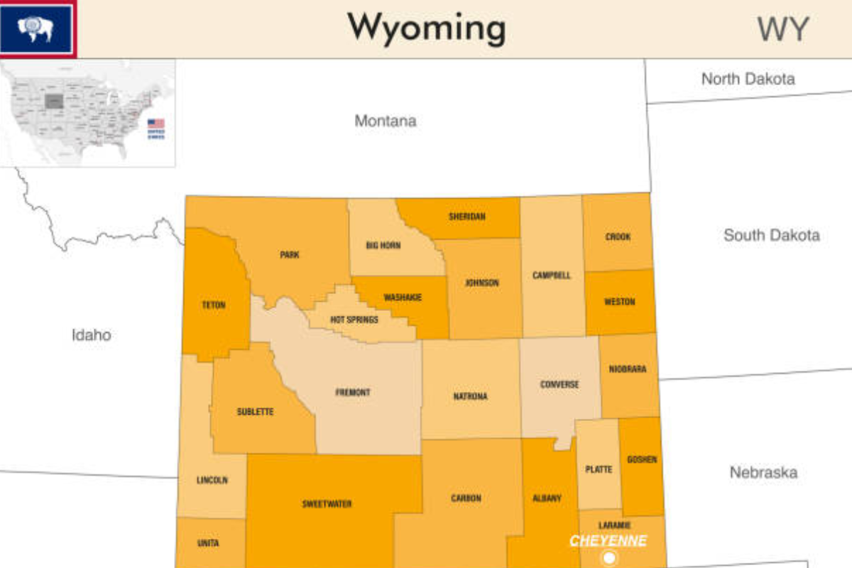
Wyoming is the 10th largest state in the United States by land area, covering approximately 97,813 square miles. Despite its vast size, it has only 23 counties, making it one of the least densely populated states. The counties vary in size, population, and economic activities, contributing uniquely to the state’s identity. A Wyoming county map provides a visual representation of these divisions, helping users identify key locations and regional characteristics.
Importance of a Wyoming County Map
A county map of Wyoming is useful for multiple purposes, including:
- Navigation: Travelers and tourists use the map to find roads, cities, and attractions within different counties.
- Historical Research: Historians and genealogists refer to county maps to study settlement patterns and historical land divisions.
- Real Estate and Land Ownership: Property buyers and real estate developers use county maps to understand jurisdiction and land boundaries.
- Political and Administrative Use: Government officials and policymakers use county maps for planning and resource allocation.
- Economic and Business Planning: Businesses rely on county maps for market analysis, supply chain management, and regional development strategies.
Breakdown of Wyoming’s 23 Counties
Each of Wyoming’s 23 counties has unique characteristics, landscapes, and economic contributions. Below is an overview of some of the most prominent counties:
1. Laramie County
Laramie County is Wyoming’s most populous county and home to Cheyenne, the state capital. It is an economic hub, featuring industries such as government, healthcare, and manufacturing. The county is also famous for hosting Cheyenne Frontier Days, the world’s largest outdoor rodeo.
2. Natrona County
Natrona County houses Casper, Wyoming’s second-largest city. It plays a significant role in the state’s energy sector, with oil, gas, and mining industries driving its economy. Outdoor recreation is also prominent, with locations such as Casper Mountain and Alcova Reservoir.
3. Teton County
Located in the northwest, Teton County is renowned for its natural beauty, including Grand Teton National Park and Jackson Hole. Tourism and outdoor recreation fuel the county’s economy, making it one of the wealthiest areas in Wyoming.
4. Sweetwater County
This county is the largest by land area and is known for its rich mineral resources, including trona and coal. Rock Springs and Green River are its major cities, offering a mix of industry and outdoor adventure.
5. Campbell County
Campbell County is a major player in Wyoming’s coal mining industry, particularly in the Powder River Basin. The city of Gillette is the county seat and serves as an economic center for energy production.
6. Albany County
Albany County is home to Laramie, where the University of Wyoming is located. The county has a strong educational and research focus, along with beautiful landscapes such as the Snowy Range Mountains.
7. Park County
Bordering Yellowstone National Park, Park County is a major tourist destination. Cody, the county seat, is known for its western heritage and attractions like the Buffalo Bill Center of the West.
8. Fremont County
Fremont County is the second-largest county in Wyoming by area and features diverse landscapes, including the Wind River Range. The county also has significant Native American heritage, as it includes the Wind River Indian Reservation.
Using a Wyoming County Map for Travel
A Wyoming county map is especially useful for travelers looking to explore the state’s diverse landscapes. Some travel-related benefits include:
- Planning Road Trips: Understanding county divisions helps in plotting scenic drives and stops along the way.
- Locating Attractions: National parks, historical sites, and outdoor recreation areas can be identified within specific counties.
- Navigating Remote Areas: Wyoming has many remote and rugged terrains where GPS signals may be weak. A county map provides a reliable backup.
Economic Significance of Wyoming Counties
Each county contributes uniquely to Wyoming’s economy, with key industries including:
- Energy Production: Counties like Campbell, Sweetwater, and Natrona play vital roles in coal, oil, and natural gas extraction.
- Tourism and Recreation: Teton, Park, and Fremont counties attract millions of visitors annually to national parks and outdoor attractions.
- Agriculture and Ranching: Rural counties, such as Platte and Niobrara, thrive on cattle ranching and farming.
- Education and Research: Albany County, with the University of Wyoming, supports higher education and scientific research.
Historical Evolution of Wyoming’s Counties
Wyoming’s counties were established over time, starting in the late 1800s when the region was still a U.S. territory. As settlers moved westward and the economy expanded, county lines were drawn to manage governance and resources efficiently. Many counties are named after early explorers, Native American tribes, or geographic features.
Accessing and Reading a Wyoming County Map
A Wyoming county map is available in various formats, including:
- Physical Maps: Paper maps are available at visitor centers, government offices, and bookstores.
- Digital Maps: Interactive online maps provide zoom-in features and real-time updates.
- GIS Systems: Geographic Information Systems (GIS) allow users to analyze spatial data and land features.
- Mobile Apps: Many travel and navigation apps include detailed county maps for Wyoming.
Conclusion
A Wyoming county map serves as an invaluable tool for navigation, research, and economic planning. Understanding the divisions within the state allows residents, businesses, and travelers to make informed decisions about routes, investments, and historical exploration. With 23 diverse counties, Wyoming offers a unique blend of natural beauty, industry, and history, making it a fascinating region to explore. Whether for travel, research, or administrative purposes, a well-detailed county map of Wyoming remains an essential resource for anyone engaging with the state’s landscape and culture.
If you would like to read more, visit our blog page.